This year, state legislatures will redraw the electoral map. The GOP controls most state legislatures, and they are expected to draw congressional districts to favor Republicans, which will make it easier for them to win a majority of seats in the House of Representatives, even if they fail to win the most votes overall. This dynamic will influence policymaking on a number of issues, including the environment. Recent events in North Carolina give some idea of what to expect.
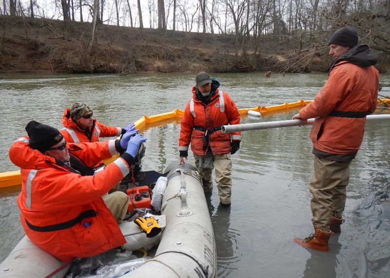
In North Carolina, coal-fired plants historically dealt with the leftover ash by mixing it with wastewater and dumping it into an open pit nearby. Because coal generators need a lot of water, power plants and coal ash ponds usually sit next to a lake or river.
This arrangement can have disastrous consequences. In 2014, a pipe under a coal ash pond owned by Duke Energy in Eden, North Carolina cracked open. The pipe carried wastewater from the nearby coal plant to the Dan River. When it broke, upwards of 30,000 tons of soggy, toxic coal ash seeped into the pipe and drained into the river.
In the aftermath, the Obama administration created the first-ever regulation on coal ash ponds, though it was remarkably weak. Michael Yaki, of the U.S. Commission on Civil Rights, later said it was “practically toothless in its ability to protect the poorest and minority population of our country from things such as coal ash.” Despite this, in 2015, the House of Representatives passed a bill that would water down the regulation even further in ways that could lead to a repeat of the Dan River spill or allow coal ash ponds to leak toxins into drinking water.
Every single Republican member of North Carolina’s congressional delegation voted in favor of the bill — including Rep. Mark Walker, whose district included the site of the Dan River spill — even as North Carolina residents living near coal ash ponds were being told not to drink well water. Every Democrat voted against it. The bill ultimately died in the Democratically-controlled Senate.
To understand why North Carolina Republicans would vote for a doomed bill to slash coal ash protections, it helps to consider their political circumstances.
In the anti-Obama fervor of 2015, it wasn’t hard to marshal Republicans against the spectre of regulatory overreach, particularly against the energy industry. While Duke Energy donated to every member of North Carolina’s congressional delegation, it gave substantially more to Republicans than to Democrats. But perhaps more important than campaign contributions or the political milieu was the impact of gerrymandering.
In 2010, Republicans came to power in North Carolina, and when they redrew the congressional map, they carved up Democratic strongholds to dilute the power of Democratic voters — namely, Black voters — creating districts that wiggled and stretched across large expanses. This practice, known as gerrymandering, produced a map that heavily favored Republicans.
In 2014, the GOP won only 55 percent of the vote statewide, but they came away with 10 out of 13 seats, and not one of these races was particularly close. Every politician Republican was well insulated against swings in public opinion. A 2014 poll from the Sierra Club found that 70 percent of North Carolina voters would be more likely to support a politician who “ favors strong regulations and enforcement… to prevent future spills,” and yet every Republican fought such rules.
Because of the way the electoral map was drawn, 12 of the 14 coal ash pond sites in North Carolina were in districts represented by Republicans, meaning that almost no one living near a coal ash pond was represented by someone who favored stronger regulations. And most coal ash pond sites are in areas that are disproportionately low-income, according to data from Earthjustice.
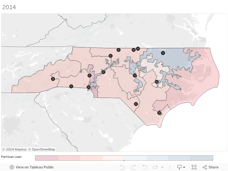
This is the North Carolina congressional map for the 2014 midterm election. The map is shaded according to the partisan lean of each district, with darker colors indicating more support for either Republicans, in red, or Democrats, in blue. The black dots indicate the locations of coal ash pond sites.
“Any environmental issue will receive less attention in a district where voting power has been diluted and divided,” said Jason Rhode, national coordinator for the Princeton Gerrymandering Project at Princeton University. “Without that voice, environmental injustice can run rampant.”
In 2016, a federal court determined that North Carolina’s congressional map had diminished the power of Black voters and ordered the legislature to redraw the map. The Republican majority produced a map that, on its face, looked more fair. But it still carved up Democratic strongholds, which typically meant Black communities, with the effect of diluting the Black vote. In the most egregious case, they drew a line through the middle of North Carolina A&T State University, the largest historically Black university in the country. The final map produced just as many Republican seats, and it left only one coal ash site in a district represented by a Democrat.
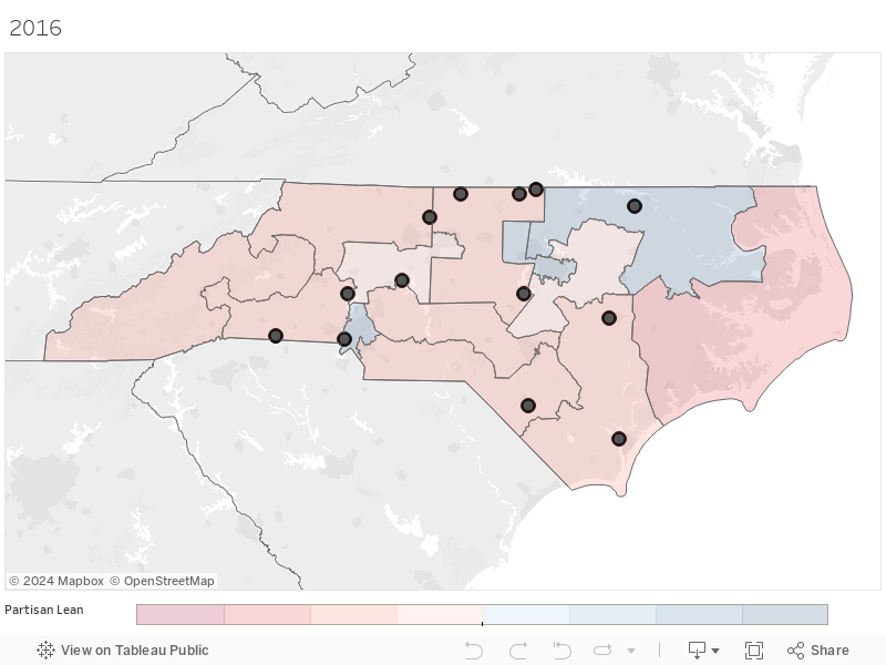
This is the North Carolina congressional map for the 2016 election. The map is shaded according to the partisan lean of each district, with darker colors indicating more support for either Republicans, in red, or Democrats, in blue. The black dots indicate the locations of coal ash pond sites.
“The government is supposed to be by the people and for the people. We’re getting further and further away from that,” said Rev. Gregory Hairston, senior pastor at Rising Star Baptist Church and a coal ash advocate.
By diluting the Black vote, he said, the Republican-controlled legislature undermined the ability of Black voters to influence policy on issues like coal ash, which disproportionately harm Black residents.
“We found that many of the issues that we faced — strokes, cancer, asthma and different neurological diseases — had developed around these centers,” Hairston said. “There is still pollution that is being put into our rivers, our basins, our water supplies.”
Gerrymandering also produces more extremes, as lawmakers in safe districts are more likely to fear a primary challenge than a general election loss. This can stymie environmental legislation, said former North Carolina state Representative Chuck McGrady, a moderate, pro-environment Republican who led the legislative response to the Dan River spill.
“The problem is that, because of gerrymandering, there is just not a lot of discussion and not a lot of ability to find compromise on a range of issues, including environmental protection,” he said. “Gerrymandering has allowed both parties to play to their base and makes it more unacceptable for anyone to compromise on whatever the issue is. It really doesn’t matter.”
In 2019, a North Carolina state court delivered another blow to North Carolina’s gerrymandered congressional map. Judges said that map was far too partisan and ordered the Republican-controlled legislature to redraw it once again. They did, and the result was a map that would send eight Republicans and five Democrats to Congress. While it was more representative than the previous map, and some districts were made more competitive, the new map still heavily tilted toward the GOP. Only three coal ash sites were in districts represented by Democrats.
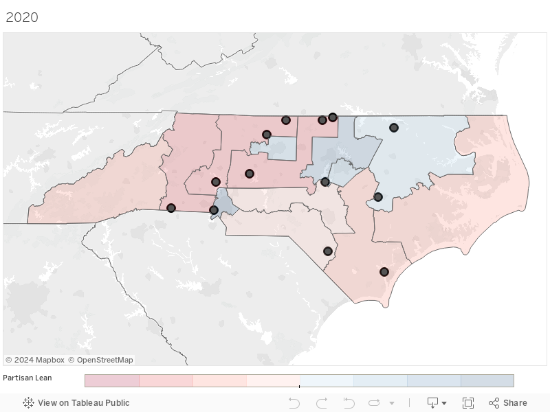
This is the North Carolina congressional map for the 2020 election. The map is shaded according to the partisan lean of each district, with darker colors indicating more support for either Republicans, in red, or Democrats, in blue. The black dots indicate the locations of coal ash pond sites.
Experts at Princeton said the more reliable way to produce a fair map is to assemble an independent citizen-redistricting commission, a bipartisan collection of citizens whose goal is to produce a fair map.
“If you have a very transparent process where the people making the decisions have the interests of the constituents at heart, that’s going to make a good map,” said Hannah Wheelen, project manager and data coordinator at the Princeton Gerrymandering Project. “Process and public involvement are what make good maps.”
In 2019, McGrady put forward a bill to overhaul North Carolina’s redistricting process. The bill calls for an independent commission to draw the map and for the legislature to vote on it. McGrady also introduced a constitutional amendment to enshrine this process. Both measures failed.
“We got so very close. I had really firm commitments in terms of the North Carolina legislature taking this up last year, and then this little pandemic arrived, and it’s just not an issue you can resolve through Zoom calls,” he said.
Now, any hopes of ending gerrymandering are likely dead, at least for a few more years. Every 10 years, states redraw the congressional map. In the 2020 election, Republicans retained their grip on the state legislature, and in 2021 they are likely to draw the map to favor the GOP. North Carolina’s democratic governor, Roy Cooper, has no veto power over the maps.
“I will continue to have an interest in making sure that our representation in the U.S. Congress more closely resembles the purple nature of our state, but I would not be surprised if my friends across the aisle take a different vantage point,” said Ben Clark, a Democrat in the North Carolina Senate.
In the last round of redistricting, Clark put forward a map that would have sent seven Republicans and six Democrats to the U.S. House of Representatives, meaning it would have been roughly representative. It failed, but it showed what a fairer map might look like.
Clark’s map preserved communities, including those affected by coal ash ponds. On his map, the Dan River coal ash pond would fall in a Democratic-leaning district that included Greensboro, which lies just 30 miles south. And the Sandhills region, a flat, sandy area on the southern side of the state would also be collected in one district.
“It just makes sense to do a Sandhills district,” he said. “They have similar historical concerns, environmental concerns.”
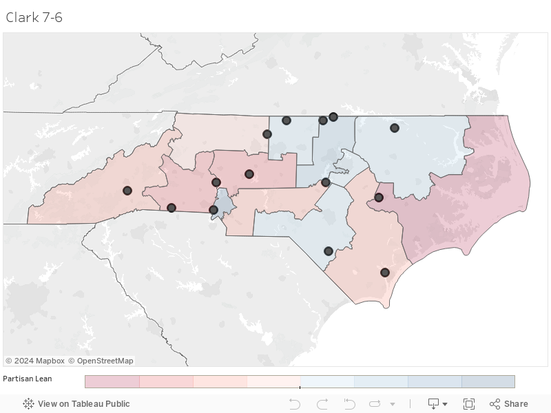
This is a North Carolina congressional map proposed by state Sen. Ben Clark. The map is shaded according to the partisan lean of each district, with darker colors indicating more support for either Republicans, in red, or Democrats, in blue. It shows the average partisan lean according to the 2018 election for the North Carolina state Senate, state House and U.S. House of Representatives. The black dots indicate the locations of coal ash pond sites.
Among those environmental concerns is the Weatherspoon coal ash pond in Lumberton. Until the pond is finally closed, it poses a threat to people who live nearby, as heavy rains could flood the pond and carry coal ash into the nearby Lumber River. Lumberton is comprised mostly of people of color. Around a third of residents live below the poverty line.
“They’re working for a living, but they don’t have a whole lot,” said Jefferson Currie II, Lumber Riverkeeper with the Winyah Rivers Alliance. “A lot of corporations over the years, they chose the path of least resistance. That meant [polluting] people who can’t necessarily litigate and fight back.”
Currently, this area is in the ninth district, which is represented by a Republican, Dan Bishop, the lead sponsor of bill requiring transgender people to use the bathroom corresponding to their sex at birth. In Clark’s map, the ninth district would lean Democratic, reflecting the partisan makeup of the Sandhills region. The sixth district, which includes the site of the Dan River spill, would also be represented by a Democrat. In total, six of the state’s 14 coal ash pond sites would be represented by Democrats. Clark’s map would also be more competitive than the current map, meaning elected officials couldn’t just play to their base.
“The best of all worlds is to have a sufficient number of districts that are truly competitive, in which the candidates have to compete on their ideas and values,” Clark said. “I don’t want a map that automatically elects all Democrats or automatically elects all Republicans.”
While North Carolina’s GOP-controlled legislature is unlikely to produce a competitive map on its own, there is some slim hope for reforming gerrymandering this year. Congress is currently considering a bill, H.R. 1, that would require states to use independent citizen-redistricting commissions to draw maps. The bill would also ban map drawers from engaging in partisan gerrymandering or breaking up relevant communities – in particular, communities of color, like North Carolina A&T State University.
Clark, however, is pessimistic about the chances of ending gerrymandering in 2021. Currie held a similarly dim view, but he said that people should rally nonetheless.
“We don’t push strong enough or hard enough. We need to say, ‘We want a nonpartisan commission or we’re gonna vote y’all out of office,’” he said. Though, he added, “I’m not expecting them to draw the most geographically and politically representational map. And if they did, I might pass out.”
Jeremy Deaton writes for Nexus Media News, a nonprofit climate change news service. You can follow him @deaton_jeremy. This story was made possible by a grant from the Open Society Foundations.